Tuesday, October 9, 2012

Stunning Lawn Hill

Pretty high up on our list of places to visit this year was Lawn Hill National Park on the Queensland/Northern Territory border, three hours north of Mount Isa or three hours south of The Gulf if you were coming down from The Savannah Way like us. Was it a long drive in there through not much? Yes. Was it worth it? Well, you be the judge...

Sunrise over Lawn Hill Gorge
Somebody call Queensland Tourism or Parks or somebody - I've got photos to sell! Our first night at Lawn Hill we stayed 10km out of the actual park at a private campground, Adels Grove - which was originally owned as a nursery for a British botanist who would grow all sorts of exotic plants on the banks of the Lawn Hill creek and send them to botanic gardens all over the world. 

It was still ridiculously hot (high 30's to 40 degrees) so we opted for an early morning sunrise walk up to the hill behind Adels Grove and watched the sun poke out above the plains. When we got back to camp we went for a quick dip in the creek before heading into the park to explore.

Sunrise over Lawn Hill

Sunrise walk to beat the heat!
Quick plunge into the waters of the creek to cool off
 The Lawn Hill creek meanders through a magnificent gorge, it doesn't run to a trickle in The Dry like most creeks, in fact in parts it is 27 feet deep just in The Dry! We decided to do a walk to a lookout over the gorge and around a big rocky island which towers above the creek below. By this time it was getting to 40 degrees with a fairly steep climb up to the lookout - pretty warm, pretty buggered but pretty spectacular!


After all that I think we stumbled into the creek down the bottom for a well deserved swim. For a gold coin donation to the RFDS you could grab a tyre tube and float on down the creek. Perfect. After our gummi adventures on the mighty Leron river in Papua, the Lawn Hill creek was pretty tame! Along the creek were steps down to gain access to the water, beautiful clean water with not much flow so you could just bob along all day.


The next day was shaping up to be just as warm so we again opted to set off in the dark just before dawn for a walk up the gorge to Indarri Falls. Breathtakingly beautiful scenery at that time of the morning when the sun just pokes over the horizon and hits the rocks. Not to mention the cool morning air which is tolerable for a walk in. 


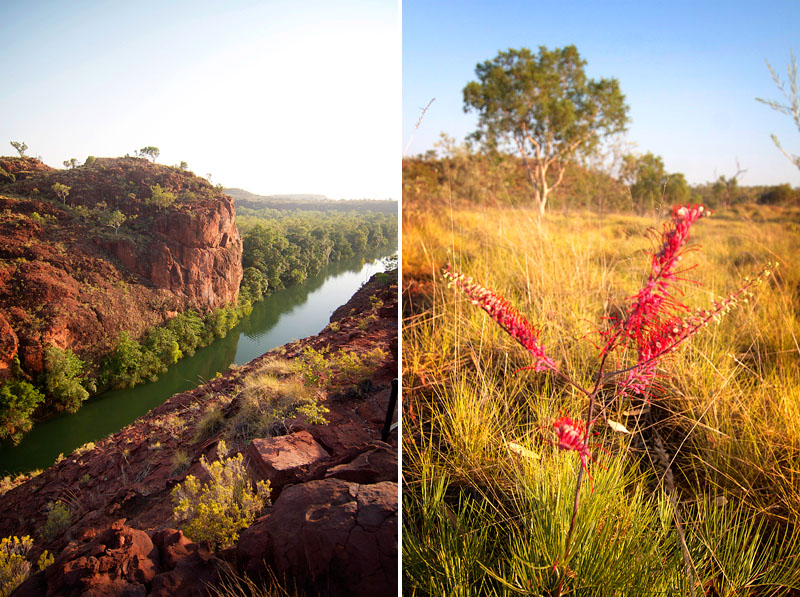
We continued on the loop walk around, heading over the rocks of the cliffs and gaining some more spectacular views over the gorge. Beautifully green also, Lawn Hill really is an oasis in the midst of the outbacks harsh environment - loads of native grasses and pretty grevillea.


Steep little descent in the track back to campsite
Back at the campsite called for another swim in the creek (obviously) before we hired a canoe to take a paddle up the creek back to Indarri Falls again. 

Matt about to take a dip and me looking out over the gorge

Our campsite at Lawn Hill
 Taking a canoe up the creek and through the gorge was a totally new perspective - along cliff faces where you can't walk and taking your time to paddle this way and that. It was truly amazing. We paddled upstream easily as there's not much flow to the creek at this time of year and arrived at Indarri Falls again (where we had walked to that morning). This time a few people had arrived for a swim and we tied our canoe up and jumped in as well.


Me swimming at Indarri

Paddle paddle paddle!
Another swim and tube ride down the creek when we return, unfortunately this is the part where our Lawn Hill adventures took a turn for the worst and Matt's wedding ring slipped off his finger (whilst trying to do a 'solo man' manoeuvre mind you) which was sad. It now rests somewhere on the bottom of the creek at the gorge. Oh well.

We love, love, loved Lawn Hill and have been telling everyone who will listen to go there, although perhaps we shouldn't - we loved it because there were not too many people, no big visitors/tourist centre or overpriced camping. The beauty of Lawn Hill is that it is so far from anywhere, and thank goodness it is.

* Apologies for some photos in this post, this is about the point where we started using Matt's little point and shoot rather than my camera. 

The Savannah Way: Across The Gulf

From our (mis)adventure being towed near Coen we headed south through Laura and the abandoned goldfields of Mount Mulligen and Tyrconnell - honestly a blog post in themselves but I'll push on as I'm so far behind with the blogging these days...

After spending four days in Cairns, getting the ute serviced, doing some shopping, getting another months worth of meat cyovac-ed, receiving some mail from home (!!!!!) we headed back up to the Atherton tablelands. For those that don't know, I am from a potato farm in Gippsland, turns out they grow potatoes and a whole lot more in Atherton also. A phone call to my Dad and 12 hours later we find ourselves on a farm tour with the friendly and obliging Frank, taking us around his different properties, talking to Matt about all things potatoes, dairy cows, lateral irrigators and centre pivots (i.e. Matt talk). Very impressive country - potatoes growing next to bananas next to canola next to pumpkins next to wheat. Crazy.

From Atherton we headed to Herberton, more old mining history and surprisingly a camera museum! Random, yes, amazing, also yes. It was actually a spy camera museum with incredible buttonhole and pocket watch spy cameras dating from the 1800's. People think that camera phones are amazing nowadays?! Loads and loads of photography history and examples of different types of cameras and photographic techniques. Needless to say all my uni lecturers droning voices came flooding back into my brain!

Matt and Frank surveying the Golden Delights

In his element - farm tour!

I taught him everything he knows...

From Herberton we headed further west to Chillagoe - another old mining town but also home to some amazing caves and Aboriginal artwork. Firstly we headed out to The Arches, then to The Balancing Rock - weather really starting to heat up into the high 30's out west. A lot of marble mining in Chillagoe so there were literally whole huge blocks of marble scattered throughout the landscape. Kitchen benchtop anyone?


We did a guided tour of the largest cave, The Royal Arch. Amazing labyrinth of caves and then opening out to large chambers, most of which are not lit or open to daylight so we had to carry highly attractive caving torches. As well as the guided tour we did two self-guided caves by ourselves, one of which was quite the tricky decline into and rock scramble out of! I'll admit I was a bit scared we'd be trapped underground for all eternity. So very dark also, take spare torch!

The Royal Arch cave

The Royal Arch cave


From Chillagoe we joined up again with The Savannah Way at Mount Surprise and continued west towards Croydon. By far the hottest day/night we've had was the day spent in Croydon and the night before on the Norman River. We didn't really have a clue at the time how hot it was, we supposed about 40 degrees, but several days later in Lawn Hill National Park it hit 40 degrees there apparently and it was cooler than in Croydon! 

Croydon is a very historic town, with a precinct in the main street with a lot of old preserved buildings such as the town hall, courthouse, gaol and hospital. There is an interactive display in the courthouse where you can listen to an actual case from 1902 and sit on the jury benches. The case was that of drunk and disorderly and swearing in the main street by one Mrs Brown! But goodness it was hot - so very, very hot. Matt thought it hilarious to lock me in the cells in such conditions?! Thankfully just out of Croydon is a large lake where Matt tried his hand at catching a barramundi (the beginning of a long and sorry saga). It was hot, did I mention that???! A swim within the croc net seemed to help.

Matt the juror in the Croydon courthouse

Well needed swim to cool down in the 42 degree heat - and being locked up in the old Croydon cells!
We continued north and finally hit Normanton, the major town on The Gulf. Here there is the giant barramundi and the giant crocodile - while is apparently life size replica of one shot in the 1970's?! A lot of very historic buildings in Normanton such as the Burns Philp Store which was gorgeous inside, old pubs and railway station which The Gulflander train still runs out of. From Normanton we headed out to Karumba where Matt did some fishing on the beach, no giant barramundi on the line so we got some local fish and chips for lunch instead. Oh. My. Goodness! Hands down the best fish I have ever had the pleasure of devouring. So good.


But west we will head...so back in Luxie and off into the sunset, still following The Savannah Way to Burketown then south to Lawn Hill National Park - one of our must-see destinations this year on our honeymoon adventures. And still the heat beat down...


Friday, October 5, 2012

To The Tip & Back Again...

So apparently the key to blogging success is consistency. If that is the case, than I am the world's worst blogger - and to think I used to be so dedicated!

That deafening silence coming from over here has been due to the fact that I lost (or left behind somewhere in Cairns) my camera's cord and I don't have a card reader with me. Disaster! So all my precious photos have been stuck on my memory cards until I could get to Katherine to buy a new card reader. Anyway, where did I leave off...

After crossing the Jardine on the ferry (the world's most exorbitant and ridiculous ferry ride, honestly if you had another half a ferry it would be called a bridge) we camped on the north banks of the river - a beautiful grassy spot on a sandy beach. We had a fire and kept a look out for crocs but didn't sight any.

Camp on the northern banks of the Jardine

The next day we continued north towards Bamaga, near the airport are some plane wrecks from WWII which we had a look at. Some were flying from Brisbane or Cairns to Papua New Guinea and crashed on the tip of Australia, some where barely scraps of metal hidden in the bush and there were hundreds and hundreds of 44 gallon fuel drums from the war rusting away in the bush, remnants of a bygone era in Australia's northern history. After checking out Bamaga, having lunch on the Seisea wharf and taking a back track to Umagico we settled in with a beer on the beach to watch the sunset over the Torres Strait - quite a moment after our journey from our wedding in Victoria almost eight months prior.

Sunset over the Torres Strait

After all the rigours of the Tele Track, Luxie didn't come out unscathed - a visit to the Bamaga mechanics, a new CV joint later and our bank balance a bit worse for wear. We drove out to Punsand Bay for the night staying at the campground there, almost to the tip! 

The next morning we checked out some more war and telegraph line relics around Punsand Bay. We ran into another young couple who coincidentally were from Healesville and worked for a owner of a farm in Yea where we used to live, we knew a lot of the same people, small world when you're traveling. We continued out on the very VERY corrugated road to The Tip. There is nothing actually at The Tip - just a rocky outcrop and a sign! We walked around the beach and mangroves and finally staked our claim of sitting on the northern most point of mainland Australia.

The rocky walk to The Tip

Made it!

It was windy. And rocky. And the seas looked shark and croc infested, treacherous! But oddly enough we had phone reception?! So we sat and called as many people as we could think of to say we were sitting at the tip of Australia. We did it!


From The Tip we headed to the old settlement of Somerset, not much there now but gravesites of pearl divers and early explorers. We met a couple from South Australia and together we did a 4WD track we probably otherwise wouldn't have done by ourselves. Luckily we did do it with another vehicle because sure enough Matt got stuck in some sand. Out came the MaxTrax (a wedding present we hoped to never have to use) but we'd spun too deep into the sand by then so our friends in the Defender had to pull us out. The beach along this east coast of The Tip was very open, exposed and barren. 

Somerset Beach - reminiscent of Papua New Guinea we thought

Luxie in a spot of bother in the sand

We headed back to Loyalty Beach campsite for two nights, time to do some washing and Matt to get the mother of all horse bites from a feral nag wandering the campsite! Then we boarded a boat at the Seisea wharf to take us over to Thursday Island for a poke around. A very interesting place - 3000 residents but only 60 rate payers due to the government owning the majority of houses. After having a look around the main street, going to the beautiful Catholic church where I said a little prayer to keep us safe on our travels, we had a beer in Australia's most northerly pub, we boarded a taxi tour of the island. It took us around the island and to the very top where the fort is - built to protect Australia from the Russians in the early 20th century! Good work. 

Me at the fort lookout on Thursday Island

The fort on top of Thursday Island - back off Russians!

The beautiful waters of the Torres Strait

Beautiful Catholic church - world's smallest 'cathedral' on Thursday Island

The local kids on the Seisia wharf

Back on mainland Australia we headed to Mutee Heads for the night where an old radar station was positioned on the hill from the war. We also drove out to the mouth of the Jardine River, nice camping but hot the day we were there walking out on the soft sand! Ugh.

Do I look hot and bothered? It was hot. I was bothered.

Back across the ferry and heading south to Vrilya Point on the west coast of the peninsula which a lot of people had recommended to us. A really slow, corrugated track in, followed by a drive along the beach past a rusted ship wreck to where we camped for the night. The tide was out in the morning so we took a walk out, collecting shells and watching the pretty sand patterns. 


Next day we headed back along the corrugated track, down the PDR a bit further and then turned into to connect back up with the Tele Track, camping the night at Sam Creek. Continuing south on the Tele Track we headed for Fruitbat Falls again - this time not so lucky with getting it to ourselves. Still a beautiful spot for a swim and freshen up!


Captain Billy Landing on the east coast of the peninsula was our next port of call. This was where the ships would dock to bring supplies to the Heathlands Station, and where the cattle would be droved to send to markets in Weipa. A large cleared area before the dunes we thought would have been a holding paddock for cattle, a ranger confirmed. Captain Billy Landing had no shelter, very exposed beach and windy. Oh my goodness, the wind! We positioned the ute to block most of it though, rolled down the camper walls and it wasn't too bad. Not much sleep that night though.

Coral washed in to Captain Billy Landing from the Great Barrier Reef 
Campdog just kicking back awaiting his coffee

Bit windy!

Onwards and upwards - well downwards, south to start the Frenchman's Track. This track connects Lockhart River to the PDR and crosses the Wenlock and the Pascoe Rivers. We had no trouble with either crossing, or along the track itself, and made camp for the night just on the east side of the Pascoe. Saw a big dingo near camp that night. We continued on to Lockhart River, which is an Aboriginal community within the Iron Range. Amazing scenery, unlike anything we'd seen on the cape - mountain ranges and open heathland.

Matt walking the Pascoe River before we cross it

Pascoe River crossing

The Iron Range

The Iron Range

The Iron Range

Beautiful native grevillia and Chilli Beach
We booked a campsite at the popular Chilli Beach and found ourselves next to fellow Victorians who we had a beer and gin and tonic with. The next morning we continued on the road south, going through the Batavia Goldfields. We came to the PDR again and as we gathered speed we were hearing a strange noise, sounding like a rock stuck in the wheel perhaps? After stopping and starting and stopping again and rattling and shaking and Matt driving whilst I listened and me driving whilst Matt listened and ran alongside the ute we finally deciphered that it could be a rear wheel bearing. Some liquid was coming from the rim - which was hot! Luck of all lucks we had literally just come into mobile reception, only 20km north of Coen. Scratching our heads we called my best friends husbands who is a diesel mechanic. No answer. Scratched our heads again as to another diesel mechanic we knew - and called trusty Thorpy who told us it more than likely is a rear wheel bearing, for God's sake don't drive it anywhere. After a few phone calls back and forth between the RACQ/RACV and them telling us the nearest tow truck could be Cooktown, some 6 hours to the south, we finally discovered that there was a RACQ tow truck in nearby Coen. He arrived soon after, poor Luxie was loaded onto the truck in the dark and we were put up for the night in the lovely guesthouse. Hot shower and breakfast, thank you very much.

Matt on the phone to Thorpy shaking poor Luxie around a bit :(
The next morning the mechanic was able to fit a new wheel bearing and we hit the road, again heading south and thanking our lucky stars we were so close to a town. We had ordered a satellite phone from Matt's brother-in-law which was awaiting us in Cairns - not soon enough!